68
Regiones Inundatae in finibus Comitatus Norfolciae, Suffolciae, Cantabrigiae, Huntingtoniae, Northam
1/7


Description
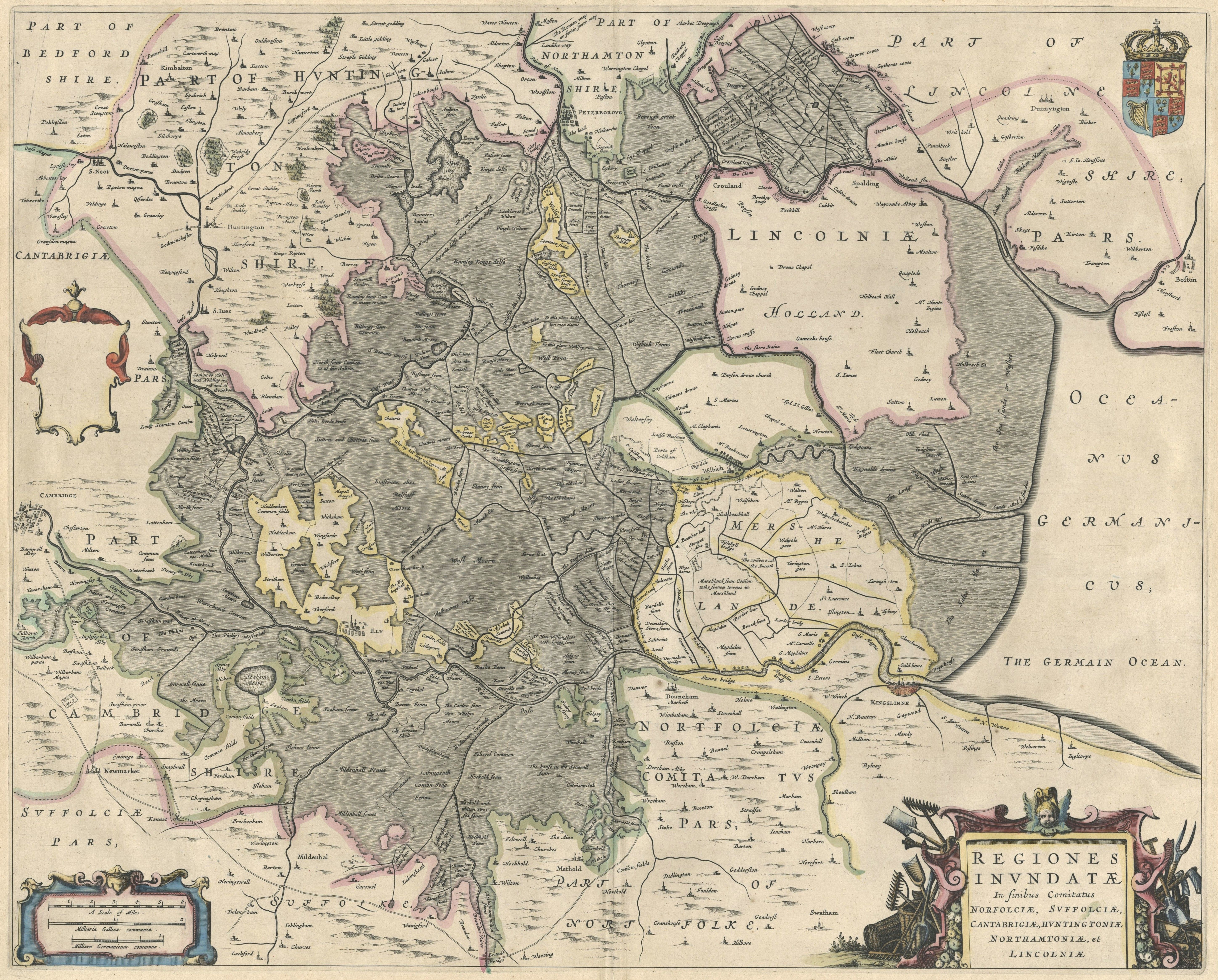
This map illustrates the Fenlands region, encompassing parts of Norfolk, Suffolk, Cambridgeshire, Huntingdonshire, Northamptonshire, and Lincolnshire. Centered around Ely, it is oriented with north to the right and lacks a compass rose. The map highlights fortified cities like Kings Lynn, Newmarket, Cambridge, and Peterborough with 3-D icons, along with roads, villages, forests, and swamps. The map is richly adorned with a coat of arms, a blank dedication cartouche, and decorative title and distance scale cartouches. About half of the map depicts water and swamp, emphasizing the historically marshy landscape where towns and cities were situated on small islands. Today, the entire region has been reclaimed, with much of it under cultivation or designated as wildlife sanctuaries. The Fens were historically an estuary of the North Sea and one of England's largest swamplands. While the Romans initiated drainage efforts, the area became marshy during the Anglo-Saxon era. Effective drainage was pioneered by Cornelius Vermuyden, a Dutch engineer, in the 17th century, with continued improvements culminating in the mid-20th century. Size: Image: 43.5 x 54.5 cm (17.1 x 21.5 inches). Condition: signs of wear. Published: Amsterdam, Blaeu c.1640. Original colour Keywords: Fenlands, Ely, Norfolk, Suffolk, Cambridgeshire, Huntingdonshire, Lincolnshire, North Sea estuary, Roman drainage, Cornelius Vermuyden, 17th-century cartography, Blaeu map, decorative cartouches, English counties, England map, British Isles map
Auction Details
Shipping
T&Cs & Important Info
This map illustrates the Fenlands region, encompassing parts of Norfolk, Suffolk, Cambridgeshire, Huntingdonshire, Northamptonshire, and Lincolnshire. Centered around Ely, it is oriented with north to the right and lacks a compass rose. The map highlights fortified cities like Kings Lynn, Newmarket, Cambridge, and Peterborough with 3-D icons, along with roads, villages, forests, and swamps. The map is richly adorned with a coat of arms, a blank dedication cartouche, and decorative title and distance scale cartouches. About half of the map depicts water and swamp, emphasizing the historically marshy landscape where towns and cities were situated on small islands. Today, the entire region has been reclaimed, with much of it under cultivation or designated as wildlife sanctuaries. The Fens were historically an estuary of the North Sea and one of England's largest swamplands. While the Romans initiated drainage efforts, the area became marshy during the Anglo-Saxon era. Effective drainage was pioneered by Cornelius Vermuyden, a Dutch engineer, in the 17th century, with continued improvements culminating in the mid-20th century. Size: Image: 43.5 x 54.5 cm (17.1 x 21.5 inches). Condition: signs of wear. Published: Amsterdam, Blaeu c.1640. Original colour Keywords: Fenlands, Ely, Norfolk, Suffolk, Cambridgeshire, Huntingdonshire, Lincolnshire, North Sea estuary, Roman drainage, Cornelius Vermuyden, 17th-century cartography, Blaeu map, decorative cartouches, English counties, England map, British Isles map
Antique maps & prints
Ends from
We offer in house shipping and shipping is handled within 3 business days of completed payment. If you have specific shipping requests or address changes, please contact us before completing payment so we are aware and can adjust the invoice if necessary. Shipping is billed directly after the sale. We typically ship via UPS, and Royal mail. We calculate based on the total package weight and destination. Each package incurs a £5 packing charge.
The buyer is responsible for paying the customs fees, duties, import taxes, and any related charges. Customs can cause delays in arrival of your shipment, which the seller has no control over. Please consider these charges and delays when making your purchase. If you need specific wording for customs, please also contact before payment as each country has different rules and we will try to accommodate when possible.
Important Information
.
Terms & Conditions
- Payment Terms
Payment for winning lots must be completed within 7 business days of the auction's conclusion. Our preffered option of payment is direct bank trasfer, we also accept credit and debit cards. Both forms of payment details will be provided to you on your invoice. - Buyer's Premium
A buyer's premium of 15% will be applied to the hammer price of each lot. This includes a 3% fee for The Saleroom and Live Auctioneers. - Condition of Lots
3.1. All Lots are sold "as is" at the time of the auction. Neither the Auctioneer nor the Seller accepts any responsibility for the condition of any Lot.
3.2. Descriptions, including those concerning authorship, attribution, authenticity, origin, date, age, period, culture, provenance, source, material, or condition, are opinions and not guarantees of fact.
3.3. Dimensions, weights, and other specifications are approximate and provided for guidance only.
3.4. Photographs are for identification purposes only and may not accurately reflect the Lot's condition, colour, or other features.
3.5. Condition reports are available upon request but are not exhaustive. - Estimates
4.1. Estimates are provided as a guide and are not a guarantee of selling price or market value. Estimates do not include the buyer's premium, VAT, or other applicable charges. - Bidding and Auctions
5.1. Bidders must register before the auction and provide valid identification and payment details.
5.2. The Auctioneer reserves the right to reject bids or withdraw Lots at any time.
5.3. All sales are final. No cancellations, refunds, or exchanges are permitted. - Liability
6.1. The Auctioneer and Seller are not liable for any loss, damage, or delay in shipment once the Lot has been handed over to the shipping carrier.
6.2. In no event shall our liability exceed the hammer price of the Lot plus the buyer's premium. - Disputes and Governing Law
7.1. Any disputes arising from the sale will be resolved under the laws of England and Wales.
7.2. By participating in our auctions, the bidder agrees to these terms and conditions without reservation.