No Image A Charles II needlework picture, worked in coloured wool with a lady amongst plants and animals, Live
No Image OMEGA, a "Pre-Moon" Speedmaster Professional, ref. 105.012-66, cal. 321, circa 1966, stainless Live
No Image A FINE CHINESE EIGHTEEN SCHOLARS BLUE AND WHITE PORCELAIN BOTTLE VASE, QING DYNASTY, KANGXI PERIOD Live
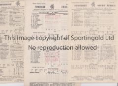
No Image Lot 896 SOMERSET C.C.C. Over 110 home and away scorecards, 82 from the 1950's including v Australia 1953 and 896SOMERSET C.C.C. Over 110 home and away scorecards, 82 from the 1950's including v Australia 1953 and Sportingold Limited SOMERSET C.C.C. Over 110 home and away scorecards, 82 from the 1950's including v Australia 1953 and 1956, Pakistan 1954, India 1959, West I... Live
No Image Lot 1266 FRANK WORTHINGTON Autographed 12 x 8 col photo of Worthington in full length action for the Tampa 1266FRANK WORTHINGTON Autographed 12 x 8 col photo of Worthington in full length action for the Tampa Sportingold Limited FRANK WORTHINGTON Autographed 12 x 8 col photo of Worthington in full length action for the Tampa Bay Rowdies, c1981, signed All The Best in ... Live
No Image Lot 2031 A LARGE ASSORTMENT OF ORDNANCE SURVEY MAPS, ETC 2031A LARGE ASSORTMENT OF ORDNANCE SURVEY MAPS, ETC Ashley Waller Auctioneers A LARGE ASSORTMENT OF ORDNANCE SURVEY MAPS, ETC Add to watchlist Live
No Image Lot 3500 END OF SALE, THANK YOU FOR YOUR BIDDING. OUR NEXT SALE IS ON THE WEDNESDAY 28TH AND THURSDAY 29TH 3500END OF SALE, THANK YOU FOR YOUR BIDDING. OUR NEXT SALE IS ON THE WEDNESDAY 28TH AND THURSDAY 29TH Ashley Waller Auctioneers END OF SALE, THANK YOU FOR YOUR BIDDING. OUR NEXT SALE IS ON THE WEDNESDAY 28TH AND THURSDAY 29TH MAY Add to watchlist Live
No Image Lot 230 World. Maffei (Giovanni), Indiarum orientalium Occidentaliumque Descriptio..., 1589 230World. Maffei (Giovanni), Indiarum orientalium Occidentaliumque Descriptio..., 1589 Dominic Winter Auctions World. Maffei (Giovanni), Indiarum orientalium Occidentaliumque Descriptio..., 1589, hand-coloured engraved map, old folds, slight marginal dust s... Add to watchlist Live
No Image Lot 231 World. Ortelius (Abraham), Typus Orbis Terrarum, [1598] 231World. Ortelius (Abraham), Typus Orbis Terrarum, [1598] Dominic Winter Auctions World. Ortelius (Abraham), Typus Orbis Terrarum, [1598], hand-coloured engraved map, ornate strapwork margin with a medallion in each corner, larg... Add to watchlist Live
No Image Lot 232 World. Stoopendahl (Daniel). Korte Beschrijuinge van de Lantschappen des Werelts, circa 1714 232World. Stoopendahl (Daniel). Korte Beschrijuinge van de Lantschappen des Werelts, circa 1714 Dominic Winter Auctions World. Stoopendahl (Daniel). Korte Beschrijuinge van de Lantschappen des Werelts, circa 1714, hand-coloured double-hemispheral 'bible' map engrave... Add to watchlist Live
No Image Lot 234 Yorkshire. Speed (John), The North and East Ridins of Yorkshire, 1616 234Yorkshire. Speed (John), The North and East Ridins of Yorkshire, 1616 Dominic Winter Auctions * Yorkshire. Speed (John), The North and East Ridins of Yorkshire, John Sudbury & George Humble [1616], engraved map with near-contemporary hand c... Add to watchlist Live
No Image Lot 277 Scotland. Illustrated London News (publishers), Glasgow, March 26th 1864 277Scotland. Illustrated London News (publishers), Glasgow, March 26th 1864 Dominic Winter Auctions * Scotland. Illustrated London News (publishers), Glasgow, March 26th 1864, uncoloured engraved panorama, old folds, some marginal closed tears, t... Add to watchlist Live
No Image Lot 317 Browne (Thomas) Pseudodoxia Epidemica: or, Enquiries into Very many received Tenents..., 1646 317Browne (Thomas) Pseudodoxia Epidemica: or, Enquiries into Very many received Tenents..., 1646 Dominic Winter Auctions Browne (Thomas). Pseudodoxia Epidemica: or, Enquiries into Very many received Tenents, and commonly presumed Truths, 1st edition, London: printed ... Add to watchlist Live
No Image Lot 350 Rushworth (John). The Tryal of Thomas Earl of Strafford, 1st edition, 1680 350Rushworth (John). The Tryal of Thomas Earl of Strafford, 1st edition, 1680 Dominic Winter Auctions Rushworth (John). The Tryal of Thomas Earl of Strafford, Lord Lieutenant of Ireland, upon an Impeachment of High Treason by the Commons then Assem... Add to watchlist Live
No Image Lot 414 THORESBY (Ralph)) Vicaria Leodiensis or the History of the Church in Leedes in Yorkshire' JOSEPH 414THORESBY (Ralph)) Vicaria Leodiensis or the History of the Church in Leedes in Yorkshire' JOSEPH Mallams THORESBY (Ralph)) Vicaria Leodiensis or the History of the Church in Leedes in Yorkshire' JOSEPH SMITH London 1724 1st Ed (/) 2 maps and 3 plates ... Add to watchlist Live
No Image Lot 419 AIKIN (John) A Description of the Country from thirty to forty miles round Manchester, Stockdale, 419AIKIN (John) A Description of the Country from thirty to forty miles round Manchester, Stockdale, Mallams AIKIN (John) A Description of the Country from thirty to forty miles round Manchester, Stockdale, London, 1795 (1st Ed.?) with maps and plates thr... Add to watchlist Live
No Image Lot 450 GILPIN (WILLIAM) Remarks on Forest Scenery and other Woodland Views…. illustrated by the scenes of 450GILPIN (WILLIAM) Remarks on Forest Scenery and other Woodland Views…. illustrated by the scenes of Mallams GILPIN (WILLIAM) Remarks on Forest Scenery and other Woodland Views…. illustrated by the scenes of New Forest in Hampshire, 3 books in 2 vols, 1st... Add to watchlist Live
No Image Lot 473 SPOTISWOODE (Sir Robert) ‘Practicks of the Laws of Scotland’. John Spotiswoode publisher. 473SPOTISWOODE (Sir Robert) ‘Practicks of the Laws of Scotland’. John Spotiswoode publisher. Mallams SPOTISWOODE (Sir Robert) ‘Practicks of the Laws of Scotland’. John Spotiswoode publisher. Edinburgh 1706, full tooled calf, 310 x 195 mm plus CRAI... Add to watchlist Live
No Image Lot 529 John Speed, “Yorkshire”,engraving, Sudbury and Humble, 39 x 51cm; Robert Morden: The West Riding 529John Speed, “Yorkshire”,engraving, Sudbury and Humble, 39 x 51cm; Robert Morden: The West Riding Mallams John Speed, “Yorkshire”,engraving, Sudbury and Humble, 39 x 51cm; Robert Morden: The West Riding of Yorkshire, 37 x 44cm; and Samuel and Nathanial... Add to watchlist Live
No Image Lot 576 A George III ordnance Survey map of the Isle of Wight published 1st June 1810 by Lt. Col. Mudge 576A George III ordnance Survey map of the Isle of Wight published 1st June 1810 by Lt. Col. Mudge Mallams A George III ordnance Survey map of the Isle of Wight published 1st June 1810 by Lt. Col. Mudge Tower, approx. 670 x 820mm, folding, plus a colle... Add to watchlist Live
No Image Lot 578 BRYANT (ANDREW) 'Map of the County of Oxford from actual survey ...in the year 1823' inscribed by 578BRYANT (ANDREW) 'Map of the County of Oxford from actual survey ...in the year 1823' inscribed by Mallams BRYANT (ANDREW) 'Map of the County of Oxford from actual survey ...in the year 1823' inscribed by permission of the Rt. Hon.The Earl of Macclesfie... Add to watchlist Live
No Image Lot 621 HENNET (G) Cartographer. A map of the County Palatine of Lancaster 1828/9 - A large scale coloured 621HENNET (G) Cartographer. A map of the County Palatine of Lancaster 1828/9 - A large scale coloured Mallams HENNET (G) Cartographer. A map of the County Palatine of Lancaster 1828/9 - A large scale coloured map laid on linen 1600 x 1050mm Add to watchlist Live
No Image Lot 655 BLACK (Adam & Charles), 'Blacks General Atlas' comprehending sixty-one maps from the latest and most 655BLACK (Adam & Charles), 'Blacks General Atlas' comprehending sixty-one maps from the latest and most Mallams BLACK (Adam & Charles), 'Blacks General Atlas' comprehending sixty-one maps from the latest and most authentic sources, engraved on steel.... by ... Add to watchlist Live
No Image Lot 694 STIRLING (Lt. Col. Walter Francis) British Army Officer & Chief Staff Officer to 'Lawrence of Arabia 694STIRLING (Lt. Col. Walter Francis) British Army Officer & Chief Staff Officer to 'Lawrence of Arabia Mallams STIRLING (Lt. Col. Walter Francis) British Army Officer & Chief Staff Officer to 'Lawrence of Arabia (1880 - 1958) 'Safety Last' Hollis & Carter... Add to watchlist Live
No Image Lot 700 BLOMFIELD. (J.C.) Compiler 'History of the Present Deanery of Bicester, Oxon' Parker & Co., 700BLOMFIELD. (J.C.) Compiler 'History of the Present Deanery of Bicester, Oxon' Parker & Co., Mallams BLOMFIELD. (J.C.) Compiler 'History of the Present Deanery of Bicester, Oxon' Parker & Co., Oxford, 1882. 2 vols with diagrams and maps, 4to, gre... Add to watchlist Live
No Image Lot 392 INSULAE QUAEDAM MINORES, FROM THE BLAEU ATLAS OF SCOTLAND 1654 392INSULAE QUAEDAM MINORES, FROM THE BLAEU ATLAS OF SCOTLAND 1654 McTear's INSULAE QUAEDAM MINORES, FROM THE BLAEU ATLAS OF SCOTLAND 1654 depicting the small islands between Mull and Skye, specifically Muck, Eigg and Cann... Add to watchlist Live
No Image Lot 571 COLLECTION OF MAPS AND BOOKS, 571COLLECTION OF MAPS AND BOOKS, McTear's COLLECTION OF MAPS AND BOOKS, including Views of Campeltown published by J. M. Brown, The Comprehensive Atlas and Guide to London Suburbs by H,J. ... Add to watchlist Live
No Image Lot 188 KOITSU ISHIWATA (1897 – 1987) Dusk at Choshi Machi 188KOITSU ISHIWATA (1897 – 1987) Dusk at Choshi Machi Azca Auctions KOITSU ISHIWATA (1897 – 1987) Dusk at Choshi Machi 1932 A woodblock print on paper depicting a traditional alley in the fading light, with a si... Add to watchlist Live
No Image Lot 232 China and Japan, travel and topography, 232China and Japan, travel and topography, Sworders China and Japan, travel and topography, including: Scenic views of China, plus a few maps (qty.)Provenance: Arthur Probsthain bookshop, London. Add to watchlist Live
No Image Lot 1197 Folio of over 120 prints and maps 1197Folio of over 120 prints and maps W&H Peacock Auctioneers & Valuers Folio of over 120 prints and maps Add to watchlist Live
No Image Lot 1234 Framed and glazed map of Huntingdon, marked Jodocus Hondius Deland Dominion 1610 1234Framed and glazed map of Huntingdon, marked Jodocus Hondius Deland Dominion 1610 W&H Peacock Auctioneers & Valuers Framed and glazed map of Huntingdon, marked Jodocus Hondius Deland Dominion 1610 Add to watchlist Live
No Image Lot 1264 5 boxes of various maps, including a good selection of Ordnance Survey 12645 boxes of various maps, including a good selection of Ordnance Survey W&H Peacock Auctioneers & Valuers 5 boxes of various maps, including a good selection of Ordnance Survey Add to watchlist Live
No Image Lot 1278 Box containing of adult colouring books 1278Box containing of adult colouring books W&H Peacock Auctioneers & Valuers Box containing of adult colouring books Add to watchlist Live
No Image Lot 1610 Robert Morden (c.1650 - 1703), a two-page coloured map, Shropshire, 36cm x 44cm, maple frame 1610Robert Morden (c.1650 - 1703), a two-page coloured map, Shropshire, 36cm x 44cm, maple frame Bamfords Auctioneers & Valuers Robert Morden (c.1650 - 1703), a two-page coloured map, Shropshire, 36cm x 44cm, maple frame Add to watchlist Live
No Image Lot 2311 A George III needlework map sampler, England and Wales, with part of Scotland and Ireland, 38cm x 2311A George III needlework map sampler, England and Wales, with part of Scotland and Ireland, 38cm x Bamfords Auctioneers & Valuers A George III needlework map sampler, England and Wales, with part of Scotland and Ireland, 38cm x 32.5cm, c.1810 Add to watchlist Live
No Image Lot 2313A A George III embroidered silk work map sampler, England and Wales, worked by S Bellott, 2313AA George III embroidered silk work map sampler, England and Wales, worked by S Bellott, Bamfords Auctioneers & Valuers A George III embroidered silk work map sampler, England and Wales, worked by S Bellott, dated 1784, approximately 59cm x 47cm, later framed and gl... Add to watchlist Live
No Image Lot 7481 A framed map/guide for excursions on the River Thames from Eton to the Nore, 55cm x 40cm 7481A framed map/guide for excursions on the River Thames from Eton to the Nore, 55cm x 40cm TW Gaze A framed map/guide for excursions on the River Thames from Eton to the Nore, 55cm x 40cm Add to watchlist Live
No Image Lot 128 A framed and glazed map of the county of Warwickshire along with a framed and glazed map of Chester 128A framed and glazed map of the county of Warwickshire along with a framed and glazed map of Chester Locke & England A framed and glazed map of the county of Warwickshire along with a framed and glazed map of Chester Add to watchlist Live
No Image Lot 161 ROBERT MORDEN (1650-1703) A map of Somerset and a map of Cornwall 161ROBERT MORDEN (1650-1703) A map of Somerset and a map of Cornwall Duke's ROBERT MORDEN (1650-1703) A map of Somerset and a map of Cornwall coloured engravings, the largest measuring 38cm x 45cm (2) Add to watchlist Live
No Image Lot 216 A motorcycle rider 'Henk Van Zalinge' The renowned inventor of the Z-Bass, overpainted print 29" 216A motorcycle rider 'Henk Van Zalinge' The renowned inventor of the Z-Bass, overpainted print 29" Amersham Auction Rooms A motorcycle rider 'Henk Van Zalinge' The renowned inventor of the Z-Bass, overpainted print 29" x 19" framed Add to watchlist Live
No Image Lot 219 ROBERT MORDEN (1650-1703) Maps of Wiltshire, Sussex and England 219ROBERT MORDEN (1650-1703) Maps of Wiltshire, Sussex and England Duke's ROBERT MORDEN (1650-1703) Maps of Wiltshire, Sussex and England three coloured engravings, the largest measuring 40cm x 47cm (3) Add to watchlist Live
No Image Lot 327 Two framed modern reproduction maps, printed on copper, after Robert Morden 17thC originals for ' 327Two framed modern reproduction maps, printed on copper, after Robert Morden 17thC originals for ' Amersham Auction Rooms Two framed modern reproduction maps, printed on copper, after Robert Morden 17thC originals for 'Darbyshire' and 'Buckinghamshire' 11" x 13" Add to watchlist Live
No Image Lot 331 A folio containing artworks along with an assortment of unframed artworks to include comical prints, 331A folio containing artworks along with an assortment of unframed artworks to include comical prints, Locke & England A folio containing artworks along with an assortment of unframed artworks to include comical prints, maps, etc Add to watchlist Live
No Image Lot 379 WILLIAM KIP (fl.c.1598-1635) A map of Dorset 379WILLIAM KIP (fl.c.1598-1635) A map of Dorset Duke's WILLIAM KIP (fl.c.1598-1635) A map of Dorset coloured engraving, 28cm x 39cm Add to watchlist Live
No Image Lot 141 JOHN ROCQUE c1769, Cumberland, engraved map, hand tinted, 20.5cm x 17cm, Northumbria, possibly 141JOHN ROCQUE c1769, Cumberland, engraved map, hand tinted, 20.5cm x 17cm, Northumbria, possibly Morphets of Harrogate JOHN ROCQUE c1769, Cumberland, engraved map, hand tinted, 20.5cm x 17cm, Northumbria, possibly Pieter Van Den Kleere (1584-c1646), engraved map, h... Add to watchlist Live
No Image Lot 142 WILLIAM HOLE (fl c1601-1624) AND CHRISTOPHER SAXTON (c1540-c1610), Eboracensis – West Riding, 17th 142WILLIAM HOLE (fl c1601-1624) AND CHRISTOPHER SAXTON (c1540-c1610), Eboracensis – West Riding, 17th Morphets of Harrogate WILLIAM HOLE (fl c1601-1624) AND CHRISTOPHER SAXTON (c1540-c1610), Eboracensis – West Riding, 17th century engraved map, hand tinted, cartouche an... Add to watchlist Live
No Image Lot 303 Atlanten - - Riedig, M. Taschen-Atlas 303Atlanten - - Riedig, M. Taschen-Atlas Nosbüsch & Stucke GmbH Auktionen Berlin Atlanten - - Riedig, M. Taschen-Atlas über alle Theile der Erde in 24 Karten gezeichnet von M. Riedig. Mit 24 (23 grenzkolorierten) Karten. Leipzi... Add to watchlist Live
No Image Lot 801 Four Map prints, Monmouth, Hereford etc. 801Four Map prints, Monmouth, Hereford etc. Nigel Ward & Company Four Map prints, Monmouth, Hereford etc. Add to watchlist Live
No Image Lot 411 Bacon (George W): Bacon's New Survey Map of South Scotland - scale 1 inch to 3 miles, folding map in 411Bacon (George W): Bacon's New Survey Map of South Scotland - scale 1 inch to 3 miles, folding map in Tayler & Fletcher Bacon (George W): Bacon's New Survey Map of South Scotland - scale 1 inch to 3 miles, folding map in original red cloth gilt covers, with combed m... Add to watchlist Live
No Image Lot 415 A full set of 97 facsimile Reprints of the first edition of the one-inch Ordnance Survey of 415A full set of 97 facsimile Reprints of the first edition of the one-inch Ordnance Survey of Tayler & Fletcher A full set of 97 facsimile Reprints of the first edition of the one-inch Ordnance Survey of England and Wales - pub. David & Charles, Newton Abbot... Add to watchlist Live
No Image Lot 168 A small map of Warwickshire, together with a framed colour print of Farmyard Fowl! 168A small map of Warwickshire, together with a framed colour print of Farmyard Fowl! Bigwood Fine Art Auctioneers A small map of Warwickshire, together with a framed colour print of Farmyard Fowl! Add to watchlist Live
No Image Lot 240 A map of the County of Bedford after C Smith, 2nd edition 1808, hand coloured, 49cm x 44cm, oak fram 240A map of the County of Bedford after C Smith, 2nd edition 1808, hand coloured, 49cm x 44cm, oak fram Bigwood Fine Art Auctioneers A map of the County of Bedford after C Smith, 2nd edition 1808, hand coloured, 49cm x 44cm, oak framed and glazed Add to watchlist Live
No Image Lot 544 Three Framed Reproduction Maps after antiquarian originals. Includes The Kingdome of England by John 544Three Framed Reproduction Maps after antiquarian originals. Includes The Kingdome of England by John Potteries Auctions Three Framed Reproduction Maps after antiquarian originals. Includes The Kingdome of England by John Speed, The Counti of Warwick and Glocestriae.... Add to watchlist Live
No Image Lot 547 Large Hydrographical Office Framed Survey of the Scilly Isles: frame size 73cm x 89.5cm 547Large Hydrographical Office Framed Survey of the Scilly Isles: frame size 73cm x 89.5cm Potteries Auctions Large Hydrographical Office Framed Survey of the Scilly Isles: frame size 73cm x 89.5cm Add to watchlist Live
No Image Lot 1006 A framed Geological Map of The British Isles, 5th edition,1969, 37'' x 25 1/2''. 1006A framed Geological Map of The British Isles, 5th edition,1969, 37'' x 25 1/2''. Nigel Ward & Company A framed Geological Map of The British Isles, 5th edition,1969, 37'' x 25 1/2''. Add to watchlist Live
No Image Lot 1080 A large map of 'Scotland of Old' surrounded by the arms of ancient local principalities, 1080A large map of 'Scotland of Old' surrounded by the arms of ancient local principalities, Nigel Ward & Company A large map of 'Scotland of Old' surrounded by the arms of ancient local principalities, clans and chiefs, printed by J. Bartholomew & Sons, 44'' ... Add to watchlist Live
No Image Lot 1125 Three framed and glazed maps of Dept of Seine et Marne, 1125Three framed and glazed maps of Dept of Seine et Marne, Nigel Ward & Company Three framed and glazed maps of Dept of Seine et Marne, Lot et Garonne from Atlas National Illustre 1851 (both frames being 15" x 21 1/4" approx) ... Add to watchlist Live
No Image Lot 1126 A framed and glazed Robert Morden Map of Cumberland, the frame being 19 1/2" x 23" approx. 1126A framed and glazed Robert Morden Map of Cumberland, the frame being 19 1/2" x 23" approx. Nigel Ward & Company A framed and glazed Robert Morden Map of Cumberland, the frame being 19 1/2" x 23" approx. Add to watchlist Live
No Image Lot 1127 A framed and glazed T. 1127A framed and glazed T. Nigel Ward & Company A framed and glazed T. Kitchen Map 'The Country Palatine of Durham, 1751, the frame being 22 3/4" x 29 1/2" approx. Add to watchlist Live
No Image Lot 1128 A framed and glazed Robert Morden map of Monmouthshire, the frame being 18 3/4" x 21 1/4" approx. 1128A framed and glazed Robert Morden map of Monmouthshire, the frame being 18 3/4" x 21 1/4" approx. Nigel Ward & Company A framed and glazed Robert Morden map of Monmouthshire, the frame being 18 3/4" x 21 1/4" approx. and another of ''The Herefordshire Hundreds'', 1... Add to watchlist Live
No Image Lot 1129 Two framed and glazed Maps: Robert Morden - Monmouthshire and North Wales, 1722, 1129Two framed and glazed Maps: Robert Morden - Monmouthshire and North Wales, 1722, Nigel Ward & Company Two framed and glazed Maps: Robert Morden - Monmouthshire and North Wales, 1722, both 20 3/4" x 22 3/4". Add to watchlist Live


![World. Ortelius (Abraham), Typus Orbis Terrarum, [1598]](https://portal-images.azureedge.net/auctions-2025/srdom10261/images/1967da78-b56f-4ff1-961c-b2d1010bdf9d.jpg?h=175)


