30
Siege of Maastricht, c.1632: Siege and Victory of the Stercke Stadt Mastrin
1/7


Description
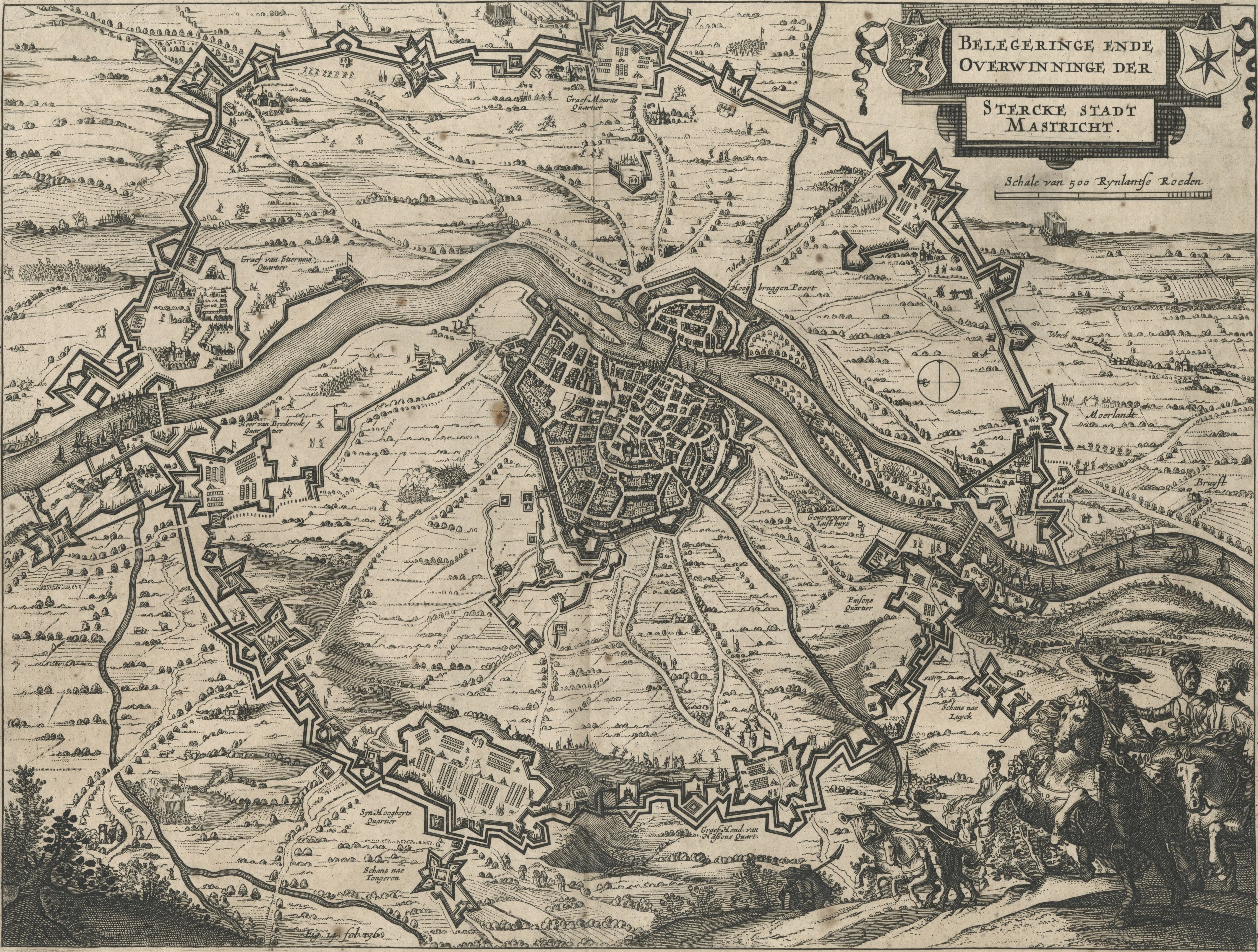
A detailed map depicting the Siege of Maastricht, which took place from 9 June to 21 August 1632, during the Eighty Years' War. The map shows the siege conducted by the State Army under Stadholder Frederik Hendrik, highlighting the various army camps surrounding the city. The scene is marked by strategic military movements and positions, with an illustration at the bottom right showing Stadholder Frederik Hendrik and officers on horseback. Condition Report: Repaired small tear to the right side, trimmed margins, and tears to the lower right corner of the margins. Image Size: 27.5 x 35.5 cm (10.8 x 14 inches). Keywords: Siege of Maastricht, 1632, Frederik Hendrik, Dutch military history, Eighty Years' War, Maastricht siege map, military cartography, historical map, 17th-century war map, State Army, Siege of Maastricht map, Dutch cartography, Maastricht city map.
Auction Details
Shipping
T&Cs & Important Info
A detailed map depicting the Siege of Maastricht, which took place from 9 June to 21 August 1632, during the Eighty Years' War. The map shows the siege conducted by the State Army under Stadholder Frederik Hendrik, highlighting the various army camps surrounding the city. The scene is marked by strategic military movements and positions, with an illustration at the bottom right showing Stadholder Frederik Hendrik and officers on horseback. Condition Report: Repaired small tear to the right side, trimmed margins, and tears to the lower right corner of the margins. Image Size: 27.5 x 35.5 cm (10.8 x 14 inches). Keywords: Siege of Maastricht, 1632, Frederik Hendrik, Dutch military history, Eighty Years' War, Maastricht siege map, military cartography, historical map, 17th-century war map, State Army, Siege of Maastricht map, Dutch cartography, Maastricht city map.
Antique maps & prints
Ends from
We offer in house shipping and shipping is handled within 3 business days of completed payment. If you have specific shipping requests or address changes, please contact us before completing payment so we are aware and can adjust the invoice if necessary. Shipping is billed directly after the sale. We typically ship via UPS, and Royal mail. We calculate based on the total package weight and destination. Each package incurs a £5 packing charge.
The buyer is responsible for paying the customs fees, duties, import taxes, and any related charges. Customs can cause delays in arrival of your shipment, which the seller has no control over. Please consider these charges and delays when making your purchase. If you need specific wording for customs, please also contact before payment as each country has different rules and we will try to accommodate when possible.
Important Information
.
Terms & Conditions
- Payment Terms
Payment for winning lots must be completed within 7 business days of the auction's conclusion. Our preffered option of payment is direct bank trasfer, we also accept credit and debit cards. Both forms of payment details will be provided to you on your invoice. - Buyer's Premium
A buyer's premium of 15% will be applied to the hammer price of each lot. This includes a 3% fee for The Saleroom and Live Auctioneers. - Condition of Lots
3.1. All Lots are sold "as is" at the time of the auction. Neither the Auctioneer nor the Seller accepts any responsibility for the condition of any Lot.
3.2. Descriptions, including those concerning authorship, attribution, authenticity, origin, date, age, period, culture, provenance, source, material, or condition, are opinions and not guarantees of fact.
3.3. Dimensions, weights, and other specifications are approximate and provided for guidance only.
3.4. Photographs are for identification purposes only and may not accurately reflect the Lot's condition, colour, or other features.
3.5. Condition reports are available upon request but are not exhaustive. - Estimates
4.1. Estimates are provided as a guide and are not a guarantee of selling price or market value. Estimates do not include the buyer's premium, VAT, or other applicable charges. - Bidding and Auctions
5.1. Bidders must register before the auction and provide valid identification and payment details.
5.2. The Auctioneer reserves the right to reject bids or withdraw Lots at any time.
5.3. All sales are final. No cancellations, refunds, or exchanges are permitted. - Liability
6.1. The Auctioneer and Seller are not liable for any loss, damage, or delay in shipment once the Lot has been handed over to the shipping carrier.
6.2. In no event shall our liability exceed the hammer price of the Lot plus the buyer's premium. - Disputes and Governing Law
7.1. Any disputes arising from the sale will be resolved under the laws of England and Wales.
7.2. By participating in our auctions, the bidder agrees to these terms and conditions without reservation.